Evacuation Information & Resources
In the event there was an Evacuation Order enacted, impacted residents would be provided with more information on evacuation routes, reception centres and online registration resources. It is important that while in an alert stage, plans for transportation, children and pets are made as access into the Order Area would be restricted. If you are not home, store your valuables and grab and go-bags outside of the alert areas.
An Evacuation Order can be issued at any time and the priority will be to get people out of the area safely.
Find the full list of updates below
August 28, 2023 – 5:45 pm
On Monday Aug. 28, the fire found a pocket of previously unburned fuels on the north side of Matevic Creek and is showing increased smoke activity. A ground crew and helicopter are on scene working together to slow fire growth. This activity is expected at elevation on the north slope and is still well within control lines and predetermined boundaries. Increases and decreases in smoke will continue to happen intermittently over the coming weeks until this fire is classified as out.
August 24, 2023 – 12:30 pm
A ridge of high pressure over Alberta will bring generally clear conditions to the area as light northerly winds come in on Thursday. By Thursday night, leading into Friday morning, elevated northerly or easterly winds can be expected. Temperatures are forecast to rebound to the low 20s by the afternoon.
Fire Update
No growth or increased fire behaviour was observed on Wednesday.
Crews will continue to monitor the fire with aviation resources and with overnight drone scans searching for hotspots in the coming days.
Until classified as “OUT” residents can expect intermittent smoke over the coming weeks as the fire finds pockets of unburnt fuel at high elevation.
This fire is no longer considered a Wildfire of Note, and this will be the final update as of August 24, 2023.
Evacuation Orders and Alerts
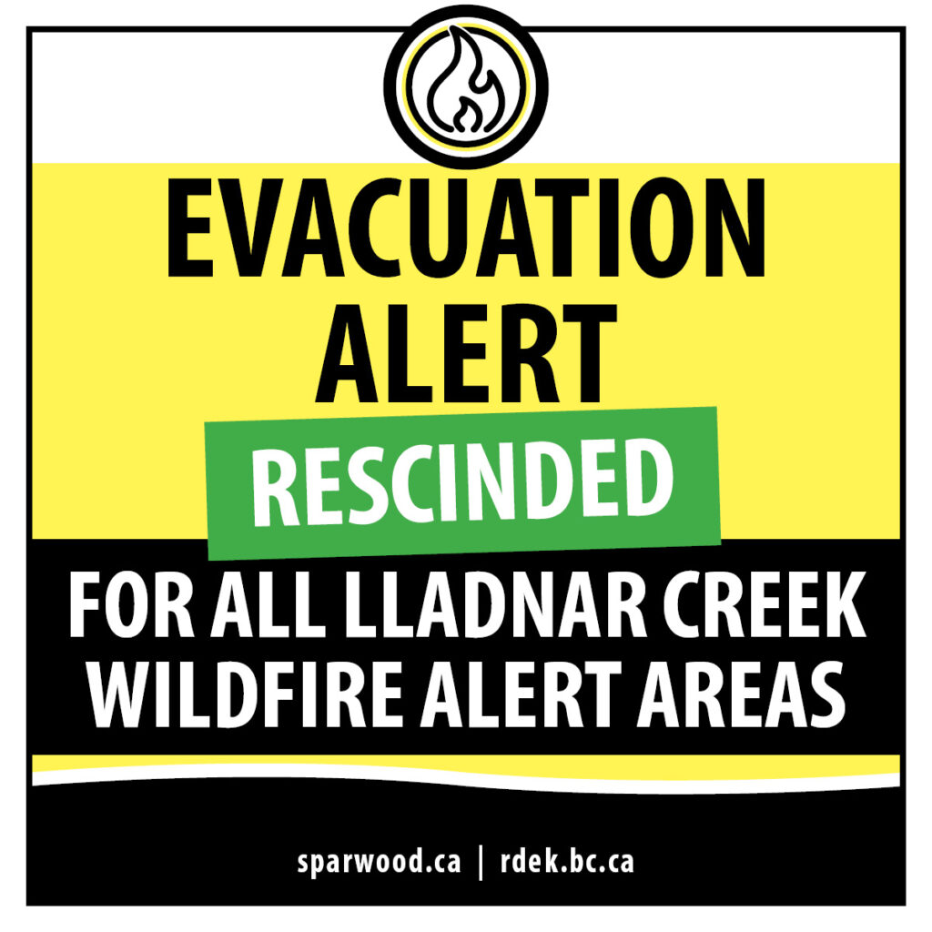
As of 3:00 pm (MDT) on August 22, all evacuation alerts have been rescinded for the Lladnar Creek wildfire.
August 23, 2023 – 12:30 pm
No growth or increased fire behaviour was observed Tuesday as precipitation continued to fall in the area.
On Wednesday, crews will be in full patrol mode, with patrols occurring throughout the afternoon.
Structure protection unit numbers continue to decrease in the area as the situation stabilizes.
The safety of the public and first responders remains the top priority.
An Incident Command Post is established at the Sparwood Recreation and Leisure Centre. For information on any impacts to usual operations at the leisure centre, please visit sprawood.recdesk.com.
August 22, 2023
The District of Sparwood and Regional District of East Kootenay (RDEK) have issued a joint Rescind of the Evacuation Alerts in the vicinity of the Lladnar Creek fire west of Sparwood. There are no longer any Evacuation Alerts in place for this fire.
“With the hard work from BC Wildfire crews and recent precipitation we are thankful to be able to rescind the Evacuation Alert for all properties impacted by the Lladnar Creek wildfire. The fire which began on July 21, has impacted our community for over a month and resulted in a significant number of properties within Sparwood and the RDEK being placed on Alert. We are immensely grateful to all those who have assisted with keeping the community safe, both on the front lines and behind the scenes. Knowing we were supported by BC Wildfire and teams from across the province provided our community with peace of mind in a time it was needed most,” says Sparwood Mayor, David Wilks.
Although the Alert has been lifted, the BC Wildfire Service continues to action the fire and it will remain an active work site. The Area Restriction remains in place and closed to public access.
“Even though the Alerts are rescinded, it is important that residents continue with FireSmart work. Conditions will continue to remain hot and dry over the summer and the efforts with protecting your property now will continue to be valuable in the weeks to come,” added Wilks.
The Alert rescind along with the corresponding maps can be found on the Evacuations and Alerts page under Emergency Information on www.rdek.bc.ca or at www.sparwood.ca.
To report a wildfire, call 1-800-663-5555 or *5555 on a mobile phone.
August 19, 2023 – 11:30 am
Gusty winds gradually diminished overnight. Fairly light northeast winds are expected today. As heavy smoke from upstream fires socked in overnight, visibility will likely be a challenge throughout the day on Saturday and could keep the temperature down, likely struggling to reach the 20-degree mark.
Overnight and through Saturday morning, this fire has exhibited minimal fire activity, mainly that of a smouldering ground fire, rank 1 fire behaviour. Control lines continue to hold. On the west and east flanks, crews are finalizing mop-up and continue to patrol. Crews are beginning to ‘demob’ equipment from areas of the fire where it is no longer required.
Structure protection crews are removing sprinklers and equipment in strategic areas as they become unnecessary.Heavy equipment and aviation resources remain engaged on this incident as required.
The safety of the public and first responders remains the top priority.
An Incident Command Post is established at the Sparwood Recreation and Leisure Centre. For information on any impacts to usual operations at the Leisure Centre, please visit the District of Sparwood website.
An area restriction is in effect in the vicinity of this wildfire.
The BC Wildfire Service reminds everyone to stay out of active fire areas. This means steering well clear of ground crews and giving plenty of room to aircraft collecting water for firefighting from lakes and other water bodies. The use of drones in active wildfire areas is strictly forbidden. Interfering with firefighting operations can slow or halt those efforts to protect our communities. And it poses enormous—potentially deadly—risks to firefighters, pilots and other response personnel, and to the public.
August 18, 2023 – 9:30 pm
Strong, erratic winds are expected to continue through Friday. These winds follow days of extremely hot and dry conditions. There is the potential for aggressive fire behaviour and high rates of spread during this weather. The BC Wildfire Service has released the following video describing this weather situation in more detail: https://youtu.be/DHgrCZDgAE8
Across the Southeast Fire Centre, increased fire behaviour and smoke may be visible. People may notice firefighting crews, heavy equipment, aircraft and other personnel working to suppress these wildfires.
The BC Wildfire Service is monitoring all fires and responding as required to help ensure public safety and protection of communities, properties and other values in our region.
We ask that everyone pay attention to local updates and alerts in your area and follow all directions regarding area restrictions and evacuation alerts and orders.
The Southwest upper flow shifting to Westerly persists Friday and winds are again expected to be gusting into the 35 km/h range as the atmosphere gradually cools. Gusty winds will persist and likely shift into the northwest early evening as a trough/cold front pushes through the area, bringing a risk of a thunderstorm. In the early evening hours, the wind direction is expected to shift to a northerly direction. Elevated winds may persist for a time overnight especially at the higher elevations.
Fire Update
Fire behaviour was low on the south, east, and west slopes; however, fire behaviour was more active on the north slope, as visible smoke occurred driven by wind into pockets of unburned fuel. Despite prolonged hot, dry, windy conditions, minimal growth was observed on Friday. As expected, control lines continued to hold.
Crews continue to patrol and mop-up of the fires edge. With increased winds, all resources are prepared to respond to flare-ups to the south and east as required.
Aviation and heavy equipment remain on site to support ground crews as required. Structure protection specialists continue to monitor and patrol. The safety of the public and first responders is the top priority.
An Incident Command Post is established at the Sparwood Recreation and Leisure Centre. For information on any impacts to usual operations at the leisure centre, please visit the District of Sparwood website.
Area Restriction
An area restriction is in effect in the vicinity of this wildfire. More information including a map of the restricted area is available here.
August 18, 2023 – 1:00 pm
Weather
Strong, erratic winds are expected to continue through Friday. These winds follow days of extremely hot and dry conditions. There is the potential for aggressive fire behaviour and high rates of spread during this weather. The BC Wildfire Service has released the following video describing this weather situation in more detail: https://youtu.be/DHgrCZDgAE8
Across the Southeast Fire Centre, increased fire behaviour and smoke may be visible. People may notice firefighting crews, heavy equipment, aircraft and other personnel working to suppress these wildfires.
The BC Wildfire Service is monitoring all fires and responding as required to help ensure public safety and protection of communities, properties and other values in our region.
We ask that everyone pay attention to local updates and alerts in your area and follow all directions regarding area restrictions and evacuation alerts and orders.
The Southwest upper flow shifting to Westerly persists Friday and winds are again expected to be gusting into the 35 km/h range as the atmosphere gradually cools. Gusty winds will persist and likely shift into the northwest early evening as a trough/cold front pushes through the area, bringing a risk of a thunderstorm. In the early evening hours, the wind direction is expected to shift to a northerly direction. Elevated winds may persist for a time overnight especially at the higher elevations.
Fire Update
Minimal fire activity observed overnight. All control lines held through the overnight and through the Friday morning period. Subdued fire behaviour as a result of the planned ignitions.
As elevated winds, low humidity, and warm temperatures are expected to continue today, fire behaviour is expected to become more visible to the surrounding areas, primarily in upper elevations on the north as winds are forecast to be higher at elevation than valley bottom.
Crews continue to patrol and mop-up of the fires edge. With increased winds, all resources are prepared to respond to flare-ups to the south and east as required.
Aviation and heavy equipment remain on site to support ground crews as required.
Structure protection specialists continue to monitor and patrol. The safety of the public and first responders is the top priority.
An Incident Command Post is established at the Sparwood Recreation and Leisure Centre. For information on any impacts to usual operations at the Leisure Centre, please visit the District of Sparwood website.
Area Restriction
An area restriction is in effect in the vicinity of this wildfire. More information including a map of the restricted area is available here.
The BC Wildfire Service reminds everyone to stay out of active fire areas. This means steering well clear of ground crews and giving plenty of room to aircraft collecting water for firefighting from lakes and other water bodies. The use of drones in active wildfire areas is strictly forbidden. Interfering with firefighting operations can slow or halt those efforts to protect our communities. And it poses enormous—potentially deadly—risks to firefighters, pilots and other response personnel, and to the public.
August 17, 2023 – 9:42 pm
Weather
Strong, erratic winds are expected to continue overnight and into Friday. These winds follow days of extremely hot and dry conditions. There is the potential for aggressive fire behaviour and high rates of spread during this weather. The BC Wildfire Service has released the following video describing this weather situation in more detail: https://youtu.be/DHgrCZDgAE8
Across the Southeast Fire Centre, increased fire behaviour and smoke may be visible. People may notice firefighting crews, heavy equipment, aircraft and other personnel working to suppress these wildfires.
The BC Wildfire Service is monitoring all fires and responding as required to help ensure public safety and protection of communities, properties and other values in our region.
The BC Wildfire Service reminds everyone to stay out of active fire areas. This means steering well clear of ground crews and giving plenty of room to aircraft collecting water for firefighting from lakes and other water bodies. The use of drones in active wildfire areas is strictly forbidden. Interfering with firefighting operations can slow or halt those efforts to protect our communities. And it poses enormous—potentially deadly—risks to firefighters, pilots and other response personnel, and to the public.
Area restrictions are in place around a number of fires in the Southeast Fire Centre. These restrictions must be respected for the safety of our responders and members of our communities. More information on area restrictions in the Southeast Fire Centre can be found here: https://www2.gov.bc.ca/gov/content/safety/wildfire-status/prevention/fire-bans-and-restrictions/southeast-fire-centre-bans#current
We ask that everyone pay attention to local updates and alerts in your area and follow all directions regarding area restrictions and evacuation alerts and orders.
Fire Update
Fire behaviour remained low on Thursday despite elevated winds and hot, dry conditions. Containment lines on the east and south of the fire held and the north flank did not grow significantly.
Monitoring and patrols will continue overnight with personnel available to respond if required. Winds are forecast to stay elevated overnight and into Friday.
Aviation and heavy equipment remain on site to support ground crews as required.
Increased smoke and fire behaviour, particularly to the north of the fire, is expected during periods of elevated winds. Structure protection specialists continue to monitor and patrol. The safety of the public and first responders is the top priority.
Heavy smoke in the valley is coming from large fires burning to the northwest in the Kamloops Fire Centre.
An Incident Command Post is established at the Sparwood Recreation and Leisure Centre. For information on any impacts to usual operations at the Leisure Centre, please visit the District of Sparwood website.
Area Restriction
An area restriction is in effect in the vicinity of this wildfire. More information including a map of the restricted area is available here.
August 17, 2023 – 3:19 pm
Weather
Thursday brings the potential for strong winds that may continue overnight and into Friday. These forecast elevated winds follow days of extremely hot and dry conditions. There is the potential for aggressive fire behaviour and high rates of spread during this weather.
Across the Southeast Fire Centre, increased fire behaviour and smoke may be visible. People may notice firefighting crews, heavy equipment, aircraft and other personnel working to suppress these wildfires.
The BC Wildfire Service is monitoring all fires and responding as required to help ensure public safety and protection of communities, properties and other values in our region.
Updates will be posted online as information is available.
The BC Wildfire Service reminds everyone to stay out of active fire areas. This means steering well clear of ground crews and giving plenty of room to aircraft collecting water for firefighting from lakes and other water bodies. The use of drones in active wildfire areas is strictly forbidden. Interfering with firefighting operations can slow or halt those efforts to protect our communities. And it poses enormous—potentially deadly—risks to firefighters, pilots and other response personnel, and to the public.
Area restrictions are in place around a number of fires in the Southeast Fire Centre. These restrictions must be respected for the safety of our responders and members of our communities. More information on area restrictions in the Southeast Fire Centre can be found here: https://www2.gov.bc.ca/gov/content/safety/wildfire-status/prevention/fire-bans-and-restrictions/southeast-fire-centre-bans#current
We ask that everyone pay attention to local updates and alerts in your area and follow all directions regarding area restrictions and evacuation alerts and orders.
Fire Update
Fire behaviour has remained minimal in the past day. On Wednesday, crews successfully conducted some small-scale planned ignitions on pockets of remaining fuel. Containment lines to the south and east of the fire are complete and ongoing patrols have not seen any areas of concern on the east flank for several days.
On Tuesday, the fire remained within these established containment lines despite stronger winds and increased fire behaviour.
Firefighters continue to mop up and strengthen and reinforce containment lines in anticipation of winds Thursday afternoon through Friday. Aviation and heavy equipment remain on site to support ground crews as required.
Increased smoke and fire behaviour, particularly to the north of the fire, is expected during periods of elevated winds. Crews will work overnight Thursday to Friday to monitor the fire and respond as required. Structure protection specialists continue to monitor and patrol. The safety of the public and first responders is the top priority.
Heavy smoke in the valley is coming from large fires burning to the northwest in the Kamloops Fire Centre.
An Incident Command Post is established at the Sparwood Recreation and Leisure Centre. For information on any impacts to usual operations at the Leisure Centre, please visit the District of Sparwood website.
Area Restriction
An area restriction is in effect in the vicinity of this wildfire. More information including a map of the restricted area is available here.
August 16, 2023 – 10:26 pm
Weather
Thursday brings the potential for strong winds that may continue overnight and into Friday. These forecast elevated winds follow days of extremely hot and dry conditions. There is the potential for aggressive fire behaviour and high rates of spread during this weather. The BC Wildfire Service has released the following video describing this situation in more detail: https://youtu.be/DHgrCZDgAE8
Across the Southeast Fire Centre, increased fire behaviour and smoke may be visible. People may notice firefighting crews, heavy equipment, aircraft and other personnel working to suppress these wildfires.
The BC Wildfire Service is monitoring all fires and responding as required to help ensure public safety and protection of communities, properties and other values in our region.
Updates will be posted online as information is available.
The BC Wildfire Service reminds everyone to stay out of active fire areas. This means steering well clear of ground crews and giving plenty of room to aircraft collecting water for firefighting from lakes and other water bodies. The use of drones in active wildfire areas is strictly forbidden. Interfering with firefighting operations can slow or halt those efforts to protect our communities. And it poses enormous—potentially deadly—risks to firefighters, pilots and other response personnel, and to the public.
Area restrictions are in place around a number of fires in the Southeast Fire Centre. These restrictions must be respected for the safety of our responders and members of our communities. More information on area restrictions in the Southeast Fire Centre can be found here: https://www2.gov.bc.ca/gov/content/safety/wildfire-status/prevention/fire-bans-and-restrictions/southeast-fire-centre-bans#current
We ask that everyone pay attention to local updates and alerts in your area and follow all directions regarding area restrictions and evacuation alerts and orders.
Fire Update
On Wednesday, crews continue to mop up from Sunday’s successful planned ignition, conduct small-scale planned ignitions on pockets of remaining fuel and patrol. Learn more about planned ignitions.
The planned ignition Sunday strengthened containment by bringing the fire from steep, inaccessible terrain down to workable ground where firefighters can suppress it. This minimizes the risk of the fire escaping control lines as elevated winds follow days of hot, dry conditions as forecast.
On Tuesday, the fire remained within these established containment lines despite stronger winds and increased fire behaviour.
Aviation and heavy equipment remain on site to support firefighters as required. Patrols are ongoing on the east flank of the fire.
Structure protection specialists continue to monitor and patrol.
Thursday is expected to bring elevated winds following days of very hot, dry conditions and fire behaviour could increase and challenge containment lines. The safety of the public and first responders is the top priority.
An Incident Command Post is established at the Sparwood Recreation and Leisure Centre. For information on any impacts to usual operations at the Leisure Centre, please visit the District of Sparwood website.
Area Restriction
An area restriction is in effect in the vicinity of this wildfire. More information including a map of the restricted area is available here.
August 16, 2023 – 12:18 pm
Weather
The Southeast Fire Centre is experiencing increased smoke and, in some areas, falling ash, on Wednesday. The smoke and ash are largely coming from fires burning to the northwest in the Kamloops Fire Centre.
Hot, dry conditions persist Wednesday with forecast highs reaching 40 C in some places. Winds are expected to be lighter than Tuesday.
Weather conditions may cause some fires to display increased behaviour and smoke. Increased winds are forecast for Thursday and personnel continue to work to prevent the fire from spreading during challenging weather.
Fire Update
On Wednesday, crews continue to mop up from Sunday’s successful planned ignition, conduct small-scale planned ignitions on pockets of remaining fuel and patrol. Learn more about planned ignitions.
The planned ignition Sunday strengthened containment by bringing the fire from steep, inaccessible terrain down to workable ground where firefighters can suppress it. This minimizes the risk of the fire escaping control lines as elevated winds follow days of hot, dry conditions as forecast.
The fire remained within these established containment lines despite stronger winds and increased fire behaviour on Tuesday afternoon.
Aviation and heavy equipment remain on site to support firefighters as required. Patrols are ongoing on the east flank of the fire.
Structure protection specialists continue to monitor and patrol.
Increased smoke and fire behaviour may continue to be visible from Sparwood and communities to the south, including Hosmer and Fernie, as hot, dry conditions persist.
An Incident Command Post is established at the Sparwood Recreation and Leisure Centre. For information on any impacts to usual operations at the Leisure Centre, please visit the District of Sparwood website.
Area Restriction
An area restriction is in effect in the vicinity of this wildfire. More information including a map of the restricted area is available here.
August 15, 2023 – 8:41 pm
Weather
Hot, dry conditions persisted across the Southeast Fire Centre with highs Tuesday expected to reach 40 C in places. Increased winds in some areas led to increased fire behaviour and smoke. Wednesday is forecast to bring similarly hot conditions with lighter winds.
Fire Update
Crews conducted a successful planned ignition on Sunday on the south side of the fire to remove unburnt fuel between the fire edge and control lines. Learn more about planned ignitions.
This operation strengthened containment by bringing the fire from steep, inaccessible terrain down to workable ground where firefighters can suppress it. This minimizes the risk of the fire escaping control lines should elevated winds follow days of hot, dry conditions as forecast.
On Monday, crews mopped up and patrolled the south flank in the planned ignition area and completed several small-scale hand ignitions to remove remaining pockets of fuel and limit the risk of any spotting beyond guards. Crews remained on site overnight to monitor and patrol the area.
On Tuesday, the fire remained within the established containment lines despite hot, dry weather coupled with elevated winds through the afternoon. Crews, along with support from aviation and heavy equipment, continued to mop up and work to contain the fire.
Structure protection specialists continue to monitor and patrol.
Increased smoke and fire behaviour may continue to be visible from Sparwood and communities to the south, including Hosmer and Fernie, as hot, dry conditions persist.
An Incident Command Post is established at the Sparwood Recreation and Leisure Centre. For information on any impacts to usual operations at the Leisure Centre, please visit the District of Sparwood website.
Area Restriction
An area restriction is in effect in the vicinity of this wildfire. More information including a map of the restricted area is available here.
August 14, 2023 – 9:31 pm
Weather
Monday brought hot, dry conditions expected to carry through Tuesday and Wednesday, followed by the potential for high winds later in the week. The BC Wildfire Service is preparing for the possibility of challenging weather by strengthening containment lines around the fire.
Planned Ignition Operation
Crews conducted a successful planned ignition on Sunday on the south side of the fire to remove unburnt fuel between the fire edge and control lines. Learn more about planned ignitions.
This operation strengthened containment by bringing the fire from steep, inaccessible terrain down to workable ground where firefighters can suppress it. This minimizes the risk of the fire escaping control lines should elevated winds follow days of hot, dry conditions as forecast.
On Monday, crews mopped up and patrolled the south flank in the planned ignition area and completed several small-scale hand ignitions to remove remaining pockets of fuel and limit the risk of any spotting beyond guards. Fire behaviour was mainly rank 2 with pockets of rank 3 in areas of the planned ignition where unburnt fuel remained. Learn more about wildfire rank.
Crews will remain on site overnight again to monitor and patrol the area. On Tuesday, crews along with support from aviation and heavy equipment will continue mopping up and working to contain the fire.
Structure protection specialists continue to monitor and patrol.
Increased smoke and fire behaviour may continue to be visible from Sparwood and communities to the south, including Hosmer and Fernie.
To view a video Q&A filmed Aug. 12 with Incident Commander Dan Klein in advance of this planned ignition, click here.
An Incident Command Post is established at the Sparwood Recreation and Leisure Centre. For information on any impacts to usual operations at the Leisure Centre, please visit the District of Sparwood website.
Area Restriction
An area restriction is in effect in the vicinity of this wildfire. More information including a map of the restricted area is available here.
August 14, 2023 – 11:36 am
Weather
A strong upper ridge continues to envelope the area bringing a forecast high of 30 C. Conditions are dry with relative humidity as low as 20 per cent. The next couple days are anticipated to be hot and dry, followed by the potential for higher winds later in the week. The BC Wildfire Service is preparing for the possibility of challenging weather by strengthening containment lines around the fire.
The fire may become more active with hot, dry conditions and increased smoke and/or flame may be visible.
Planned Ignition Operation
Crews conducted a successful planned ignition on Sundayon the south side of the fire to remove unburnt fuel between the fire edge and control lines. Learn more about planned ignitions.
This operation strengthened containment by bringing the fire from steep, inaccessible terrain down to workable ground where firefighters can suppress it. This minimizes the risk of the fire escaping control lines should elevated winds follow days of hot, dry conditions as forecast.
On Monday, crews may continue some small-scale planned ignitions in the Lladnar Creek drainage to burn several remaining pockets of fuel.
Firefighters with support from aircraft and heavy equipment will continue to monitor and mop up the planned ignition site. Structure protection specialists are patrolling the area as well. Crews remained on site overnight to ensure the fire stayed within the planned ignition site.
Increased smoke may continue to be visible from Sparwood and communities to the south, including Hosmer and Fernie.
Expect the posted fire size to increase to reflect this planned ignition.
To view a video Q&A filmed Aug. 12 with Incident Commander Dan Klein in advance of this planned ignition, click here.
An Incident Command Post is established at the Sparwood Recreation and Leisure Centre. For information on any impacts to usual operations at the Leisure Centre, please visit the District of Sparwood website.
Area Restriction
An area restriction is in effect in the vicinity of this wildfire. More information including a map of the restricted area is available here.
August 13, 2023 – 8:04 pm
Weather
Sunday brought sunnier skies along with warmer and drier conditions. The next few days are anticipated to be increasingly hot and dry, followed by the potential for high winds late in the week (Aug. 17-20). The BC Wildfire Service is preparing for the possibility of challenging weather by strengthening containment lines around the fire.
Planned Ignition Operation
Crews conducted a successful planned ignition on Sundayon the south side of the fire to remove unburnt fuel between the fire edge and control lines. Learn more about planned ignitions. This operation strengthened containment by bringing the fire down from steep, inaccessible terrain down to workable ground where firefighters can suppress it. This minimizes the risk of the fire escaping control lines should elevated winds follow days of hot, dry conditions as forecast.
Firefighters with support from aircraft and heavy equipment will continue to monitor and mop up the planned ignition site. Structure protection specialists are patrolling the area as well. Crews will remain on site overnight.
On Monday, crews will complete the operation by burning several remaining pockets of fuel within the planned ignition area.
Increased smoke may continue to be visible from Sparwood and communities to the south, including Hosmer and Fernie.
To view a video Q&A filmed Aug. 12 with Incident Commander Dan Klein about this planned ignition operation, click here.
An Incident Command Post is established at the Sparwood Recreation and Leisure Centre. For information on any impacts to usual operations at the Leisure Centre, please visit the District of Sparwood website.
Area Restriction
An area restriction is in effect in the vicinity of this wildfire. More information including a map of the restricted area is available here.
August 13, 2023 – 10:52 am
Weather
Sunday is expected to bring sunnier skies along with warmer and drier conditions. Temperatures are forecast to reach a high of 27 C.
The next few days are anticipated to be increasingly hot and dry followed by the potential for high winds late in the week (Aug. 17-20). The BC Wildfire Service is preparing for the possibility of challenging weather by strengthening containment lines around the fire.
Planned Ignition Operation
Crews supported by an ignition specialist are conducting a planned ignition on Sunday on the south side of the fire to remove unburnt fuel between the fire edge and control lines. Learn more about planned ignitions. This operation will strengthen containment by bringing the fire from its current location on steep, inaccessible terrain down to workable ground where firefighters can suppress it. This minimizes the risk of the fire escaping control lines should elevated winds follow days of hot, dry conditions as forecast.
Control lines have been built and reinforced with water delivery systems around the area identified for the planned ignition. During the operation, firefighters, heavy equipment and aircraft will protect the perimeter of the area while structure protection specialists patrol and monitor.
Hand and aerial ignitions will be used during the operation, which could begin as early as noon Sunday. People in the area should expect to see an increase in activity and smoke while the planned ignition is underway. Increased smoke may also be visible south of the fire around the communities of Hosmer and Fernie.
The planned ignition will only proceed if site and weather conditions are optimal. To view a video Q&A with Incident Commander Dan Klein about this planned ignition operation, click here.
An Incident Command Post is established at the Sparwood Recreation and Leisure Centre. For information on any impacts to usual operations at the Leisure Centre, please visit the District of Sparwood website.
Site Conditions and Fire Behaviour
Fire behaviour is generally low (rank 1 and 2). Small pockets of heightened fire activity (rank 3) was observed Saturday during late afternoon peak burning time and are expected again Sunday. Learn more about wildfire rank.
August 12, 2023 – 1:23 pm
Weather
Saturday is expected to bring a mix of sun and cloud with increasing winds at ridgetop elevation starting in the afternoon and continuing into the evening. Temperatures are forecast to be moderate, with a high of 23 C.
The next few days are anticipated to be increasingly hot and dry followed by the potential for high winds late next week (Aug. 17-20). The BC Wildfire Service is preparing for the possibility of challenging weather by strengthening containment lines around the fire.
Site Conditions and Fire Behaviour
Fire behaviour is generally low (rank 1 and 2). Small pockets of heightened fire activity (rank 3) was observed Friday during late afternoon peak burning time and is expected again Saturday. Learn more about wildfire rank.
Operations
Crews supported by an ignition specialist are preparing to conduct a planned ignition on the south side of the fire to remove unburnt fuel between the fire edge and control lines. Learn more about planned ignitions. This operation will strengthen containment by bringing the fire from its current location on steep, inaccessible terrain down to workable ground where firefighters can suppress it. This minimizes the risk of the fire escaping control lines should elevated winds follow days of hot, dry conditions as forecast.
Control lines have been built and reinforced with water delivery systems around the area identified for the planned ignition. During the operation, firefighters, heavy equipment and aircraft will protect the perimeter of the area while structure protection specialists patrol and monitor.
Hand and aerial ignitions will be used during the operation. People in the area should expect to see an increase in aircraft activity and smoke while the planned ignition is underway.
The planned ignition could begin as early as Sunday. It will only proceed when site and weather conditions are optimal.
Structure protection personnel remain on site to assess, plan and set up structure protection as required in areas of potential concern.
An Incident Command Post is established at the Sparwood Recreation and Leisure Centre. For information on any impacts to usual operations at the Leisure Centre, please visit the District of Sparwood website.
August 12, 2023 – 10:00 am
Weather
Saturday is expected to bring a mix of sun and cloud with increasing winds at ridgetop elevation starting in the afternoon and continuing into the evening. Temperatures are forecast to be moderate, with highs of 23 C.
Site Conditions and Fire Behaviour
Fire behaviour is low (rank 1) with minimal change in the last 24 hours. Learn more about wildfire rank.
Operations
Heavy equipment and ground crews continue building guards on the south and east flanks of the fire.
Specialists are preparing to conduct a planned ignition on the south flank in coming days when conditions are appropriate. This operation will remove unburnt fuels between the fire’s edge and guards to strengthen containment and minimize the risk of the fire spreading beyond the guard. Learn more about planned ignitions.
Increased smoke and activity will be visible from the area when this operation is underway.
Structure protection personnel remain on site to assess, plan, and set up structure protection as required in areas of potential concern.
An Incident Command Post is established at the Sparwood Recreation and Leisure Centre. For information on any impacts to usual operations at the Leisure Centre, please visit the District of Sparwood website.
August 11, 2023 – 6:59 pm
Weather
Generally light winds are forecast for Friday as conditions trend towards warming and drying. A mix of sun and cloud has the potential for isolated, minor showers over high terrain as temperatures top-out in the mid-20s.
Site Conditions and Fire Behaviour
Fire behaviour is low (rank 1) with minimal change in the last 24 hours. Learn more about wildfire rank.
Operations
Heavy equipment and ground crews continue building guards on the south and east flanks of the fire.
Specialists are preparing to conduct a planned ignition on the south flank in coming days when conditions are appropriate. This operation will remove unburnt fuels between the fire’s edge and guards to strengthen containment and minimize the risk of the fire spreading beyond the guard. Learn more about planned ignitions. Increased smoke and activity will be visible from the area when this operation is underway.
Structure protection personnel remain on site to assess, plan, and set up structure protection as required in areas of potential concern.
An Incident Command Post is established at the Sparwood Recreation and Leisure Centre. For information on any impacts to usual operations at the Leisure Centre, please visit www.sparwood.ca.
August 11, 2023 – 12:15 pm
Weather
Generally light winds are forecast for Friday as conditions trend towards warming and drying. A mix of sun and cloud has the potential for isolated, minor showers over high terrain as temperatures top-out in the mid-20s.
Site Conditions and Fire Behaviour
Fire behaviour has been reduced throughout the site and minimal change has occurred in the last 24 hours. Observed fire behaviour throughout the area is rank 1. Learn more about wildfire rank.
Operations
Heavy equipment will be working with ground crews on the south and east flanks of the fire as guards continue to be constructed in preparation for planned ignitions. These ignitions will be dependant on site and weather conditions; more information will be available when conditions are optimal on site.
Patrols continue for ground crews as personnel continue to monitor burn operations that took place on August 6.
Structure protection personnel remain on site to assess, plan, and set up structure protection as required in areas of potential concern.
An Incident Command Post is established at the Sparwood Recreation and Leisure Centre. For information on any impacts to usual operations at the Leisure Centre, please visit the District of Sparwood website.
August 10, 2023 – 6:00 pm
Weather
The Lladnar Creek wildfire received between 3-5 mm of precipitation on Wednesday, with the greatest totals in the southern section. A dry, more stable northwesterly flow on Thursday will be the beginning of a warming and drying trend that is expected to last five or more days. Moderate winds are possible from the north or northwest, while isolated showers build over high terrain Thursday afternoon. Expect temperatures to reach the mid-20s by this afternoon.
Site Conditions and Fire Behaviour
Fire behaviour has been significantly reduced throughout the site and no changes have occurred in the last 24 hours. Observed fire behaviour throughout the area is rank 1. Learn more about wildfire rank.
Operations
Heavy equipment will be working with ground crews in the southern section of the fire as guards continue to be constructed in preparation for planned ignitions. These ignitions will be dependent on site and weather conditions; more information will be available when conditions are optimal on site.
Patrols continue for ground crews as personnel continue to monitor burn operations that took place on August 6.
Structure protection personnel remain on site to assess, plan, and set up structure protection as required in areas of potential concern.
An Incident Command Post is established at the Sparwood Recreation and Leisure Centre. For information on any impacts to usual operations at the Leisure Centre, please visit the District of Sparwood website.
August 9, 2023 – 5:35 pm
Weather
Cool temperatures and high humidity values are forecast for Wednesday as an upper trough pushes a weakening cold front eastward into the Lladnar Creek area. With a chance of showers in the evening and overnight on Wednesday, the potential for gusty wind can also be anticipated in the area. These winds have the potential of shifting from the south or southwest to west or northwest overnight.
Site Conditions and Fire Behaviour
Fire behaviour has been significantly reduced throughout the site. Observed fire behaviour throughout the area is rank 1. Learn more about wildfire rank.
Operations
Patrols continue for ground crews as personnel continue to monitor burn operations that took place on August 6.
Hand and equipment guards are being established on the southern flank, from Lladnar Creek to the transmission lines, for future planned ignitions.
Structure protection personnel remain on site to assess, plan, and set up structure protection as required in areas of potential concern.
An Incident Command Post is established at the Sparwood Recreation and Leisure Centre. For information on any impacts to usual operations at the Leisure Centre, please visit the District of Sparwood website.
August 8, 2023 – 12:05 pm
Weather
Greater than 10 mil of precipitation was recorded on the fire on Monday. By Tuesday afternoon, bands of warm-frontal moisture should bring thickening bands of system cloud (and a risk of a convective shower) while southerly or southwesterly winds potentially come up a notch. Elevated southwesterly winds continue Tuesday night, especially at higher elevations ahead of a weakening cold front that brings gusty winds, variable cloud, isolated showers, and cooler temperatures on Wednesday.
Site Conditions and Fire Behaviour
No growth was observed. Fire behaviour has been significantly reduced throughout the site. On the east slope, there is minimal fire activity due to the planned ignition and downturn in weather. Observed fire behaviour throughout is rank 1. Learn more about wildfire rank.
Operations
Crews will continue to monitor the east slope for potential fire activity.
North of Cummings Creek, crews are finalizing the hand guard where heavy equipment could not access.
To the south, crews are establishing a fuel-free hand guard that will effectively tie the Lladnar Creek into the Elk River. This work is expected to be completed in the next operational period.
Structure protection personnel remain on site to assess, plan and set up structure protection as required in areas of potential concern.
August 7, 2023 – 5:30 pm
The fire is receiving a measurable amount of precipitation. Temperatures will fall a degree or two each day and relative humidity will continue to rise in response to the daily threat of showers and thunderstorms.
Site Conditions and Fire Behaviour
A response officer flew the fire Monday morning to monitor Sunday’s burn site from the air and map the fire size. It is now mapped at 945 hectares. The size increase is mainly a result of Sunday’s planned ignition. As a result of Sunday’s planned ignition and the rainfall, onsite fire behaviour is rank 1 throughout. Learn more about wildfire rank.
Operations
Control lines held overnight on the east slope, where the planned ignition was on Sunday. Crews are monitoring the burn operations on the east slope with non-stop patrols to ensure that control lines continue to hold.
The machine guard north of Cummings Creek is now complete. Crews are now positioned in the area to establish hand guard in that area. To the north, crews are establishing a trail west from Cummings Creek and scouting areas for potential planned ignitions in the area should they be required.
To the south, crews are establishing a fuel-free that will effectively tie the Lladnar Creek into the Elk River. Ground crews are being supported by helicopters in this area.
Structure protection personnel remain on site to assess, plan and set up structure protection as required in areas of potential concern.
An Incident Command Post is established at the Sparwood Recreation and Leisure Centre. For information on any impacts to usual operations at the leisure centre, please visit the District of Sparwood website. While the BC Wildfire Service and firefighters are grateful for the incredible amount of community support, we are currently unable to accept donations of any kind.
Drone in Restricted Airspace
On Sunday, helicopters were not able to lift for a brief period of time as a drone was in the airspace. The BC Wildfire Service and Transport Canada remind the public that the airspace around and over any wildfire is closed to all aircraft not associated with fire suppression activities – including drones. The presence of drones near active wildfire operations presents a significant safety risk for aircraft, which can slow down or completely shut down aerial firefighting efforts delaying this vital support to firefighting personnel and the wider community. In the interest of aircrew and public safety, British Columbians are asked to keep their drones well away from wildfires. You could face serious penalties, including fines and/or jail time, should you be caught operating a drone in the vicinity of a wildfire.
August 6, 2023 – 6:00 pm
A weak upper low over southern Washington state will push instability and subtropical moisture northward into the area Sunday. Increased cloud cover, smoke and isolated showers will result with slightly cooler temperatures and higher relative humidity. There is the potential for showers or thundershowers on Monday.
Site Conditions and Fire Behaviour
No significant growth was noted overnight, the size increase is partially a result of Saturday’s burn operations. The broader planned ignition is complete, successfully achieving ignition objectives on the east slope. Fire behaviour on the ignition area was consistently a highly vigorous surface fire (rank 4). With Sunday’s ignition complete, fire behaviour is now noted to be predominantly rank 2. Learn more about wildfire rank.
Operations
With Sunday’s burn successfully complete, the majority of the east slope has been tied into the guard at the toe of the slope. Crews will remain on site into the evening to monitor the fire to ensure that control lines continue to hold. The guard planned for north of Cummings Creek is now complete.
Structure protection personnel remain on site to assess, plan and set up structure protection as required in areas of potential concern.
An Incident Command Post is established at the Sparwood Recreation and Leisure Centre. For information on any impacts to usual operations at the leisure centre, please visit the District of Sparwood website. While the BC Wildfire Service and firefighters are grateful for the incredible amount of community support, we are currently unable to accept donations of any kind.
Drone in Restricted Airspace
On Sunday, helicopters were not able to lift for a brief period of time as a drone was in the airspace. The BC Wildfire Service and Transport Canada remind the public that the airspace around and over any wildfire is closed to all aircraft not associated with fire suppression activities – including drones. The presence of drones near active wildfire operations presents a significant safety risk for aircraft, which can slow down or completely shut down aerial firefighting efforts delaying this vital support to firefighting personnel and the wider community. In the interest of aircrew and public safety, British Columbians are asked to keep their drones well away from wildfires. You could face serious penalties, including fines and/or jail time, should you be caught operating a drone in the vicinity of a wildfire.
August 6, 2023 – 10:50 am
Weather
A weak upper low over southern Washington state will push instability and subtropical moisture northward into the area Sunday. Increased cloud cover, smoke and isolated showers will result with slightly cooler temperatures and higher relative humidity. There is the potential for showers or thundershowers on Monday.
Site Conditions and Fire Behaviour
No significant growth was noted overnight, the size increase is partially a result of Saturday’s burn operations. Humidity has increased in the area and onsite fire behaviour on Sunday morning was noted at rank 1 with pockets of rank 2. Learn more about wildfire rank.
Operations
Site and weather conditions continue to be favourable for further broad-scale hand igntions on the east slope Sunday. Crews will be beginning these ignitions late morning. Residents can expect to see an increase in fire behaviour on the ignition site, with a medium intensity rank 3 / 4 fire behaviour expected on the ignition site. This increased fire behaviour is required to achieve objectives and remove fuel from the fires path. This burn will happen by hand and will be ‘slope-driven’ which means that the fire will be managed to spread upslope and away from the community. Heavy equipment and aviation resources will assist crews in managing this ignition and an additional 10 firefighters have been assigned to support.
These planned ignitions will be highly visible to the community, smoke is expected to increase as a result.
Planned ignitions remove unburnt fuel between the fire edge and control lines in an intentional manner to reduce the chance of the fire spreading beyond control lines. Learn more about planned ignitions.
Ground crews, heavy equipment and rotary wing aircraft are assigned to this incident along with Structural Protection Resources. Responder and public safety remain the top priority.
An Incident Command Post is established at the Sparwood Recreation and Leisure Centre. For information on any impacts to usual operations at the Leisure Centre, please visit the District of Sparwood website.
While the BC Wildfire Service and firefighters are grateful for the incredible amount of community support, we are currently unable to accept donations of any kind.
August 5, 2023 – 11:20 am
Weather
As sub-tropical moisture continues to drift North, humidity is expected to slightly increase today and temperatures are forecast to be cooler than Friday. A risk of convective activity continues during the afternoon and evening hours.
Site Conditions and Fire Behaviour
As forecast, humidity has improved and fire activity reduced Saturday morning, on site fire behaviour this morning is noted at rank 1. Learn more about wildfire rank. Growth over the past 24 hours has been minimal. The little growth that occurred was at high elevation away from the community.
Operations
Friday’s small-scale hand ignitions to reinforce the guard were completed successfully. As humidity improves and only light winds are forecast, ground crews are preparing for broader-scale hand ignitions over the next 48 hours on the east slope.
Saturday, crews are preparing by developing what is referred to as a blackline, where fuels are burned to develop a fuel-free barrier and reinforce control lines prior to increasing the scope of ignitions.
Site conditions are expected to become even more favourable on Sunday for crews to complete the burn on the east slope. This burn will happen by hand and will be ‘slope-driven’ which means that the fire will be managed to spread upslope and away from the community.
This broader hand ignition will continue if site conditions and the forecast align for a burn window. Heavy equipment and aviation resources will assist crews in managing this ignition. An additional eight BC Wildfire personnel arrived today to support.
These planned ignitions will be highly visible to the community, smoke is expected to increase as a result.
Planned ignitions remove unburnt fuel between the fire edge and control lines in an intentional manner to reduce the chance of the fire spreading beyond control lines. Learn more about planned ignitions.
Ground crews, heavy equipment and rotary wing aircraft are assigned to this incident along with Structural Protection Resources. Responder and public safety remain the top priority.
An Incident Command Post is established at the Sparwood Recreation and Leisure Centre. For information on any impacts to usual operations at the leisure centre, please visit the District of Sparwood website.
While the BC Wildfire Service and firefighters are grateful for the incredible amount of community support, we are currently unable to accept donations of any kind.
August 4, 2023 – 6:55 pm
Weather
Winds are expected to remain light today, though can become elevated in this valley. Slightly cooler temperatures are forecast for today with a bump in relative humidity. There is a 30% chance of showers and a risk of thundershowers later in the afternoon.
Site Conditions and Fire Behaviour
Diminished fire behaviour remains noted during the early morning and afternoon hours at rank 1. Fire behaviour often increases during the peak burning period in the evening when the temperatures are highest and the humidity is lowest. This increase in visible activity during the peak burning period is common on wildfires. Learn more about wildfire rank.
A response officer was able to fly the fire late in the morning on Friday to obtain an accurate track, including areas that had reduced visibility Thursday. As a result of overnight growth, the fire is now mapped at 751 hectares. With this increased visibility, growth was noted on all sides of the fire, with the majority of growth attributed to the south slope and a bowl at high elevation to the north.
Operations
Steep and rocky terrain, along with an increased safety risk from danger trees, keeps ground crews working from the control line at the toe of the slope. A small amount of growth on the east slope continues to be noted and crews have safely completed small-scale hand ignitions on the control lines where the fire has reached the lines. These hand ignitions have been happening regularly over the course of this fire and are expected to continue on the east slope when and where the fire reaches the control lines. Learn more about planned ignitions.
Conditions on site and the weather forecast have not aligned for an optimal window and the aerial ignition that was planned for Friday the east slope is not happening today.
Ground crews, heavy equipment and rotary wing aircraft are assigned to this incident along with Structural Protection Resources. Responder and public safety remain the top priority.
An Incident Command Post is established at the Sparwood Recreation and Leisure Centre. For information on any impacts to usual operations at the leisure centre, please visit the District of Sparwood website. While the BC Wildfire Service and firefighters are grateful for the incredible amount of community support, we are currently unable to accept donations of any kind.
August 4, 2023 – 10:00 am
Weather
Winds are expected to remain light today, though can become elevated in this valley. Slightly cooler temperatures are forecast for today with a bump in relative humidity. There is a 30% chance of showers and a risk of thundershowers later in the afternoon.
Site Conditions and Fire Behaviour
Overnight conditions on the Lladnar Creek wildfire was rank 3 with pockets of rank 4, which is a moderate to highly vigorous surface fire with candling. In the morning hours, it has settled back into rank 1 fire behaviour – a smouldering ground fire with little open flame. Learn more about wildfire rank.
Downslope growth was noted on the south slope. Control lines tied into the Matevic Draw held overnight. No significant spotting was noted during the active overnight burning period.
Operations
Conditions on site and the weather forecast have not aligned for an optimal window and the planned aerial ignition will not be moving ahead today that was planned for the east slope.
Steep and rocky terrain, along with an increased safety risk from danger trees, keeps ground crews working from the control line at the toe of the slope. On the east slope, crews will continue to do some small-scale hand ignition operations to strengthen containment where possible as the fire reaches control lines. Learn more about planned ignitions.
Ground crews, heavy equipment and rotary wing aircraft are assigned to this incident along with Structural Protection Resources. Responder and public safety remain the top priority.
This fire will continue to be monitored overnight. It is very visible from Sparwood and residents can expect to see active fire behaviour overnight.
An Incident Command Post is established at the Sparwood Recreation and Leisure Centre. For information on any impacts to usual operations at the Leisure Centre, please sparwood.recdesk.com.
August 3, 2023 – 9:55 pm
Weather
Persisting dry conditions and high temperatures in the mid-30 C range are forecast across the fire centre on Thursday. Variable light winds from the northwest below 15 km/h, with the risk of gusting as conditions become slightly less stable throughout the day. A downturn in weather is forecasted on Friday, with the potential for precipitation.
Site Conditions and Fire Behaviour
This wildfire experienced growth towards the north today (August 3, 2023). Fire behaviour increased in this area as we have experienced a rebound from the rain earlier this week meaning conditions are hot and dry and fuels are more susceptible for increased fire behaviour. These dry fuels were the driver of this growth. Learn more about wildfire rank.
Operations
Conditions were not favorable to complete aerial ignition efforts on the east side of the fire today. Ignition operations will be reassessed over the coming days and will only be implemented if weather and site conditions are favorable.
Planned ignitions remove unburnt fuel between the fire edge and control lines in an intentional manner to reduce the chance of the fire spreading beyond control lines. Learn more about planned ignitions.
Crews have an established secondary guard east of the fire and will work to reinforce this tomorrow and in the coming days, Ground crews, heavy equipment and rotary wing aircraft are assigned to this incident along with Structural Protection Resources. Responder and public safety remain the top priority.
This fire will continue to be monitored overnight. It is very visible from Sparwood and residents can expect to see active fire behaviour overnight.
Structure protection personnel are on site to assess, plan and set up structure protection as required in areas of potential concern.
An Incident Command Post is established at the Sparwood Recreation and Leisure Centre. For information on any impacts to usual operations at the Leisure Centre, please visit sparwood.recdesk.com.
August 3, 2023 – 2:14 pm
Weather
Persisting dry conditions and high temperatures in the mid-30 C range are forecast across the fire centre on Thursday. Variable light winds from the northwest below 15 km/h, with the risk of gusting as conditions become slightly less stable throughout the day. A downturn in weather is forecasted on Friday, with the potential for precipitation.
Site Conditions and Fire Behaviour
The fire saw some growth on Wednesday as was expected due to planned hand ignitions. The fire saw Rank 4 at times during the planned ignition (highly vigorous surface fire with torching or passive crown fire), but once ignitions were complete, the fire dropped back down to a Rank 3 (moderately vigorous surface fire) overnight. Learn more about wildfire rank.
Operations
Ground crews successfully completed planned hand ignitions in the north section of the fire over the evening and into the night on Wednesday. The ignition saw minimal crown fire and remained at a low intensity for most of the burn. No significant spotting was witnessed during the burn. Crews will be back in the area Thursday as mop-up continues.
Pending ideal weather and site conditions on Thursday, ground crews will be supporting aerial ignition efforts on the east side of the fire. This aerial ignition operation will commence late in the afternoon and into the evening, above the transmission lines. Ground crews will be supporting the aerial team at the bottom of the slope as the ignitions begin at the top section and slowly work downhill. This burn is expected to bring smoke and ash to the surrounding areas.
Planned ignitions remove unburnt fuel between the fire edge and control lines in an intentional manner to reduce the chance of the fire spreading beyond control lines. Learn more about planned ignitions.
Structure protection personnel are on site to assess, plan and set up structure protection as required in areas of potential concern.
An Incident Command Post is established at the Sparwood Recreation and Leisure Centre. For information on any impacts to usual operations at the Leisure Centre, please visit sparwood.recdesk.com.
August 2, 2023 – 6:22 pm
Wednesday brings extremely dry conditions with temperatures peaking into the mid-30 C range across the Southeast Fire Centre. Variable winds of 10-24 km/h gusting up to 30-45 km/h with higher in isolated areas are expected, starting in the afternoon and carrying through the evenings.
Site Conditions and Fire Behaviour
The fire has seen minimal growth in recent days and continues to burn mainly as a smouldering ground fire (rank 1, with rank 2 observed during peak burning hours on Monday). Learn more about wildfire rank.
Operations
Crews completed preliminary planned ignitions on the north side of the fire Tuesday evening. Hand ignitions will continue Wednesday evening as conditions allow. The operation, targeting a 26-hectare area, is supported by sprinklers and ground crews.
Plans are also being finalized for a combined aerial and hand ignition operation that could begin as early as Thursday along the east flank of the fire. An increase in smoke and aircraft in the vicinity should be expected when this operation is underway.
Planned ignitions remove unburnt fuel between the fire edge and control lines in an intentional manner to reduce the chance of the fire spreading beyond control lines. Learn more about planned ignitions.
Firefighters also continue to bolster control lines in the Matevic drainage area and establish hoselay. Guard on the north side of the fire will be tied into a slide path to help contain fire growth to the north.
Structure protection personnel are on site to assess, plan and set up structure protection as required in areas of potential concern. These crews are working into the evening to assess fire growth and movement.
An Incident Command Post is established at the Sparwood Recreation and Leisure Centre. For information on any impacts to usual operations at the Leisure Centre, please visit sparwood.recdesk.com.
August 1, 2023 – 12:15 pm
The fire continues to burn mainly as a smouldering ground fire (rank 1, with rank 2 observed during peak burning hours on Monday). Learn more about wildfire rank.
Operations
Ground crews are establishing hand guard to the north of the fire in the Matevic drainage, which will be tied into a slide path to help contain fire growth to the north. Crews will conduct small-scale hand ignitions in this area on Tuesday evening or later this week when conditions allow.
This tactic removes unburnt fuel between the fire edge and control lines in an intentional manner to reduce the chance of the fire spreading beyond control lines. Learn more about planned ignitions.
Fire growth has been minimal in recent days. Guards are complete from Cummings Creek in the north to Lladnar Creek in the south.
Aviation resources and ground crews are also responding to new fire starts in the area as required. We appreciate quick reporting by residents.
Structure protection personnel are on site to assess, plan and set up structure protection as required in areas of potential concern.
An Incident Command Post is established at the Sparwood Recreation and Leisure Centre. For information on any impacts to usual operations at the Leisure Centre, please visit sparwood.recdesk.com.
July 31, 2023 – 12:00 pm
Site Conditions and Fire Behaviour
The fire received 5-8 mils of rain on Sunday under a passing thunderstorm, this precipitation reduced fire behaviour. Observed fire behaviour Saturday and Sunday morning is a smouldering ground fire (rank 1). Learn more about wildfire rank.
A drier, but still unstable southwesterly flow should support above-average southerly or southwesterly winds again Monday afternoon (although not as gusty as Sunday) with sunnier skies, warmer temperatures, and lower humidities than Sunday. Poor venting overnight with smoke drift in the valley variable or towards the south.
Operations
Sunday’s thunderstorm produced lightning in the area. Aviation resources and ground crews assigned to this fire have been responding to nearby incidents as they are detected. We would like to thank residents for their quick reporting.
Only minimal growth was observed on the fire has been observed in recent days. Guards are complete from Cummings Creek in the north to Lladnar Creek in the south. Ground crews are working on building a control line to the Matevic drainage and establishing a fuel free from the Lladnar FSR to the tower.
Plans are complete for contingency lines south, tying into large slide paths on the east face of Mt. Hosmer that work as natural containment.
As weather and site conditions allow, crews will continue small-scale hand ignitions on the east flank to anchor the fire to the guard. This tactic removes unburnt fuel between the fire edge and control lines in an intentional manner to reduce the chance of the fire spreading beyond control lines.
Structure protection personnel are on site to assess, plan and set up structure protection as required in areas of potential concern.
An Incident Command Post is established at the Sparwood Recreation and Leisure Centre, which is hosting approximately 125 personnel responding to this fire. For information on any impacts to usual operations at the leisure centre, please visit the District of Sparwood website.
Resources
Heavy equipment are continuing work on control lines. Aircraft are available to support the work of ground crews.
July 30, 2023 – 8:00 pm
Site Conditions and Fire Behaviour
Observed fire behaviour Saturday and Sunday morning is a smouldering ground fire (rank 1 and 2). Learn more about wildfire rank.
Winds are expected to increase on Sunday afternoon as the risk of a thundershower increases in the afternoon, otherwise temperatures and humidities similar to Saturday.
Operations
Only minimal growth was observed on the fire on Saturday and into Sunday. On the north side, the fire continued to progress downslope into Matevic Draw. On the east flank, the fire is slowly moving downslope and meeting the control line. Guards are complete from Cummings Creek in the north to Lladnar Creek in the south. Plans are complete for contingency lines south, tying into large slide paths on the east face of Mt. Hosmer that work as natural containment.
On Saturday, crews continued small-scale hand ignitions to anchor the fire to the guard. This tactic removes unburnt fuel between the fire edge and control lines in an intentional manner to reduce the chance of the fire spreading beyond control lines and anchor the fire to the machine guard. These small-scale planned ignitions are likely to continue on the east flank as the fire comes down to secure control lines. Learn more about planned ignitions here.
Firefighters are also establishing water-delivery systems and hoselay in critical areas. Structure protection personnel are on site to assess, plan and set up structure protection as required in areas of potential concern. Crews remain overnight to monitor fire growth and suppress any spots as they occur.
Resources
The BC Wildfire Service is increasing resources in the Sparwood area. The increased presence of BCWS personnel, equipment, operational staff and others related to firefighting efforts will be visible to the community in the coming days.
Fire behaviour has remained stable. The influx of firefighters, structure protection specialists, heavy equipment and operators, along with several helicopters, is an element of the BC Wildfire Service’s response as it works to contain the fire and protect the community. More resources mean objectives can be accomplished more quickly, safely and effectively.
Ground crews clear and reinforce control lines, as well as monitor and patrol, while heavy equipment pushes in machine guard to help prevent the fire from spreading. Helicopters can drop water to cool the fire and slow its growth while structure protection crews assess and install protective equipment as needed.
As there was no change to fire behaviour or suppression tactics, there is no operational video update. The most recent video update on operations with BCWS Incident Commander Daniel Klein and Regional District of East Kootenay Communications Manager Loree Duczek filmed July 29th is available here.
An Incident Command Post is established at the Sparwood Recreation and Leisure Centre, which is hosting approximately 125 personnel responding to this fire.
Aviation Resources
Aircraft are available to support the work of ground crews.
July 29, 2023 – 12:10 pm
Site Conditions and Fire Behaviour
The fire is a smouldering ground fire (rank 1 and 2) with pockets of rank 3 in areas of heavy fuel accumulation. Learn more about wildfire rank.
The area received a small amount of precipitation in the past 48 hours which has helped reduce fire behviour. Generally light winds are expected Saturday morning. An upper ridge building from the south on Friday should bring sunnier and warmer conditions until patchy subtropical moisture approaching from the south-southwest threatens with high-based, dry thunderstorms in in the afternoon or evening.
Operations
Southward growth continues to be minimal. On the north side, the fire continued to progress downslope into Matevic Draw. On the east flank, the fire is slowly moving downslope and meeting the control line. Guards are complete from Cummings Creek in the north to Lladnar Creek in the south. Plans are complete for contingency lines south, tying into large slide paths on the east face of Mt. Hosmer that work as natural containment.
On Saturday, crews continued small-scale hand ignitions to anchor the fire to the guard. This tactic removes unburnt fuel between the fire edge and control lines in an intentional manner to reduce the chance of the fire spreading beyond control lines and anchor the fire to the machine guard. These small-scale planned ignitions are likely to continue on the east flank as the fire comes down to secure control lines. Learn more about planned ignitions here.
Firefighters are also establishing water-delivery systems and hoselay in critical areas. Structure protection personnel are on site to assess, plan and set up structure protection as required in areas of potential concern. Crews remain overnight to monitor fire growth and suppress any spots as they occur.
Resources
The BC Wildfire Service is increasing resources in the Sparwood area. The increased presence of BCWS personnel, equipment, operational staff and others related to firefighting efforts will be visible to the community in the coming days.
Fire behaviour has remained stable. The influx of firefighters, structure protection specialists, heavy equipment and operators, along with several helicopters, is an element of the BC Wildfire Service’s response as it works to contain the fire and protect the community. More resources mean objectives can be accomplished more quickly, safely and effectively.
Ground crews clear and reinforce control lines, as well as monitor and patrol, while heavy equipment pushes in machine guard to help prevent the fire from spreading. Helicopters can drop water to cool the fire and slow its growth while structure protection crews assess and install protective equipment as needed.
An Incident Command Post is established at the Sparwood Recreation and Leisure Centre, which is hosting approximately 125 personnel responding to this fire.
Aviation Resources
Aircraft are available to support the work of ground crews.
Evacuation Orders and Alerts
The District of Sparwood has issued an evacuation ALERT due to this wildfire. For the latest information on evacuation alerts and orders, visit the District of Sparwood website.
The BC Wildfire Service recommends evacuation orders or alerts to local governments based on areas of potential concern after considering a number of factors including: site conditions and weather, current and forecast fire behaviour and the presence of natural containment features.
Currently, wildfire officers on the Lladnar Creek wildfire have deemed evacuation alerts for Sparwood are only recommended for Sparwood Heights south of Sparwood Heights Drive and residences on Matevic Road. This is due to these areas being in closest proximity to the fire and most likely impacted in the event of unexpected downslope growth over containment lines. Wildfire officers continue to monitor fire progression and will extend alerts if weather, fire behaviour and forecasted fire growth render it necessary.
While the BC Wildfire Service recommends evacuation orders and alerts, local authorities are responsible for implementing them.
Evacuation alerts mean you may need to evacuate, sometimes with little or no notice. An evacuation alert is the time to get prepared by, for example, putting essentials in a “grab-and-go” bag and planning accommodation should you need to leave your home. More information on evacuation preparation and emergency planning is available at www.preparedbc.ca.
July 28, 2023 – 1:00 pm
Site Conditions and Fire Behaviour
The fire is a smouldering ground fire (rank 1 and 2) with pockets of rank 3 in areas of heavy fuel accumulation. Learn more about wildfire rank.
Friday is expected to be sunny, slightly warmer and drier than Thursday. Risk of an afternoon thunderstorm remains; otherwise, winds are forecast to be light northerlies. Saturday brings hotter, drier temperatures with a slightly greater chance of a thunderstorm.
Operations
Southward growth has been minimal. On the north side, the fire continues to progress downslope into Matevic Draw. On the east flank, the fire is slowly moving downslope and meeting the control line. Guards are complete from Cummins Creek in the north to Lladnar Creek in the south. On Friday, crews continue small-scale hand ignitions to anchor the fire to the guard. This tactic removes unburnt fuel between the fire edge and control lines in an intentional manner to reduce the chance of the fire spreading beyond control lines. Learn more about planned ignitions here.
Firefighters are also establishing water-delivery systems and hoselay in critical areas.
Structure protection personnel are on site, developing plans to install equipment as a precautionary measure if needed in Sparwood Heights and other areas of concern.
Resources
The BC Wildfire Service is increasing resources in the Sparwood area. The increased presence of BCWS personnel, equipment, operational staff and others related to firefighting efforts will be visible to the community in the coming days.
Fire behaviour has remained stable. The influx of firefighters, structure protection specialists, heavy equipment and operators, along with several helicopters, is an element of the BC Wildfire Service’s response as it works to contain the fire and protect the community. More resources mean objectives can be accomplished more quickly, safely and effectively.
Ground crews clear and reinforce control lines, as well as monitor and patrol, while heavy equipment pushes in machine guard to help prevent the fire from spreading. Helicopters can drop water to cool the fire and slow its growth while structure protection crews assess and install protective equipment as needed.
For the most recent video update on operations with BCWS Incident Commander Daniel Klein and Regional District of East Kootenay Communications Manager Loree Duczek, click here.
An Incident Command Post is established at the Sparwood Recreation and Leisure Centre, which is hosting approximately 125 personnel responding to this fire. For information on any impacts to usual operations at the leisure centre, please visit the District of Sparwood website.
Aviation Resources
Aircraft are available Friday to support the work of ground crews.
Evacuation Orders and Alerts
The District of Sparwood has issued an evacuation ALERT due to this wildfire. For the latest information on evacuation alerts and orders, visit the District of Sparwood website.
The BC Wildfire Service recommends evacuation orders or alerts to local governments based on areas of potential concern after considering a number of factors including: site conditions and weather, current and forecast fire behaviour and the presence of natural containment features.
Currently, wildfire officers on the Lladnar Creek wildfire have deemed evacuation alerts for Sparwood are only recommended for Sparwood Heights south of Sparwood Heights Drive and residences on Matevic Road. This is due to these areas being in closest proximity to the fire and most likely impacted in the event of unexpected downslope growth over containment lines. Wildfire officers continue to monitor fire progression and will extend alerts if weather, fire behaviour and forecasted fire growth render it necessary.
While the BC Wildfire Service recommends evacuation orders and alerts, local authorities are responsible for implementing them. For more information on the evacuation alert due to the Lladnar Creek Wildfire, visit the District of Sparwood website
Evacuation alerts mean you may need to evacuate, sometimes with little or no notice. An evacuation alert is the time to get prepared by, for example, putting essentials in a “grab-and-go” bag and planning accommodation should you need to leave your home. More information on evacuation preparation and emergency planning is available at www.preparedbc.ca.
July 27, 2023 – 6:00 pm
The BC Wildfire Service is increasing resources in the Sparwood area. The increased presence of BCWS personnel, equipment, operational staff and others related to firefighting efforts will be visible to the community in the coming days.
Fire behaviour has remained stable for the past couple of days. The influx of firefighters, structure protection specialists, heavy equipment and operators, along with several helicopters, is an element of the BC Wildfire Service’s response as it works to contain the fire and protect the community. More resources mean objectives can be accomplished more quickly, safely and effectively.
Ground crews clear and reinforce control lines, as well as monitor and patrol, while heavy equipment pushes in machine guard to help prevent the fire from spreading. Helicopters can drop water to cool the fire and slow its growth while structure protection crews assess and install protective equipment as needed.
For the most recent video update on operations with BCWS Incident Commander Daniel Klein and Regional District of East Kootenay Communications Manager Loree Duczek, click here.
Operational support staff is based at the Sparwood Recreation and Leisure Centre. For information on any impacts to usual operations contact the Sparwood Leisure Center at sparwood.recdesk.com or 250.425.0552.
District of Sparwood Update
The District of Sparwood would like to extend a huge thank you to BC Wildfire Services and the many firefighters who have arrived to assist. We sincerely appreciate the support and effort going in to manage the Lladner Creek Wildfire.
Secondly, thank you to Sparwood residents for staying calm and keeping informed. It is important we continue to work together to share information and updates. Please reach out and connect with friends and neighbours who many not have access to the internet to check in and provide them with information.
July 27, 2023 – 2:00 pm
July 27, 2023 – 11:24 pm
The fire is a smouldering ground fire (rank 1 and 2) with pockets of rank 3 in areas of heavy fuel accumulation. Learn more about wildfire rank. Temperatures Thursday are expected to range from 27 to 32 C. Winds are forecast to be variable from 8 to 18 km/h with gusts of 20-30 km/h. Relative humidities are low and a risk of thunderstorms is present across the fire centre. Winds accompanying thunderstorms may be stronger and erratic. Temperatures are expected to be hotter on Friday, which also brings a heightened risk of thunderstorms and lightning.
Operations
The fire is reaching to machine guard that runs parallel to transmission lines at the bottom of the slope and crews will continue to do small-scale hand ignitions to anchor it to the guard. This tactic removes unburnt fuel between the fire edge and control lines in an intentional manner to reduce the chance of the fire spreading beyond control lines. Small-scale planned ignitions began Wednesday and will continue Thursday and in coming days if and when conditions are favourable. Learn more about planned ignitions here.
On Thursday, heavy equipment continues pushing machine guard south toward Lladnar Creek and north above Sparwood Heights to Cummings Creek. Firefighters are also establishing water-delivery systems and hoselay in critical areas.
Structure protection personnel are on site, assessing properties and developing plans to install equipment as a precautionary measure if needed in Sparwood Heights and other areas of concern.
Aviation Resources
Aircraft are assisting ground crews on Thursday as needed to cool the fire’s edge and slow growth downslope as firefighters and heavy equipment construct guard to help prevent spread toward the community. Helicopters will bolster those efforts where it is safe and effective to do so.
Evacuation Orders and Alerts
The District of Sparwood has issued an evacuation ALERT due to this wildfire. For the latest information on evacuation alerts and orders, visit the District of Sparwood website.
The BC Wildfire Service recommends evacuation orders or alerts to local governments based on areas of potential concern after considering a number of factors including: site conditions and weather, current and forecast fire behaviour and the presence of natural containment features.
Currently, wildfire officers on the Lladnar Creek wildfire have recommended evacuation alerts only for the area of Sparwood Heights south of Sparwood Heights Drive along with residences on Matevic Road. This is due to these areas being in closest proximity to the fire and most likely impacted in the event of unexpected downslope growth over containment lines. Wildfire officers continue to monitor fire progression and will extend alerts if weather, fire behaviour and forecasted fire growth render it necessary.
While the BC Wildfire Service recommends evacuation orders and alerts, local authorities are responsible for implementing them. For more information on the evacuation alert due to the Lladnar Creek Wildfire, visit the District of Sparwood website
Evacuation alerts mean you may need to evacuate, sometimes with little or no notice. An evacuation alert is the time to get prepared by, for example, putting essentials in a “grab-and-go” bag and planning accommodation should you need to leave your home. More information on evacuation preparation and emergency planning is available at www.preparedbc.ca.
July 26, 2023 – 7:46 pm
The fire is a smouldering ground fire (rank 1 and 2) with pockets of rank 3 in areas of heavy fuel accumulation. Learn more about wildfire rank. The fire size is mapped at 343 hectares. Wednesday was forecast to be sunny, warm and dry with variable, but generally light, winds. On Thursday, there is potential for thunderstorms bringing dry lighting and gusting winds.
Operations
On Wednesday, heavy equipment and firefighters worked to put in machine guard along the BC Hydro right-of-way at the bottom of the slope. Crews worked to prepare water-delivery systems and establish hoselay in critical areas.
Crews will be looking for opportunities to conduct small-scale hand ignitions to remove unburnt fuel between the fire edge and control lines in an intentional manner to reduce the chance of the fire spreading beyond control lines. These small-planned ignitions began Wednesday. Hand ignitions will be ongoing in the coming days when conditions allow. Learn more about planned ignitions here.
Structure protection personnel are on site, assessing and installing equipment to protect structures as needed.
Aviation Resources
Aircraft are assisting ground crews on Wednesday as needed to cool the fire’s edge and slow growth downslope. The fire has moved further downslope and heavy equipment and firefighters are constructing machine guard and wetline to help prevent spread toward the community. Helicopters will bolster those efforts where it is safe and effective to do so.
While wildfire management relies on a fleet of reliable and capable aircraft to assist firefighters on the ground, there are several incidents where the use of aircraft can have unintended negative consequences. It is the job of experienced personnel on the ground, in the zone, in operations, and in aviation to decide whether the use of aircraft would do more harm than good. With ground crews available to help mitigate potential negative impacts, officers will determine how to best use available aviation resources to assist in fire suppression.
Evacuation Orders and Alerts
The District of Sparwood has issued an evacuation ALERT due to this wildfire.
The BC Wildfire Service recommends evacuation orders or alerts to local governments based on areas of potential concern after considering a number of factors including: site conditions and weather, current and forecast fire behaviour and the presence of natural containment features.
Currently, wildfire officers on the Lladnar Creek wildfire have deemed evacuation alerts for Sparwood are only recommended for Sparwood Heights south of Sparwood Heights Drive and residences on Matevic Road. This is due to these areas being in closest proximity to the fire and most likely impacted in the event of unexpected downslope growth over containment lines. Wildfire officers continue to monitor fire progression and will extend alerts if weather, fire behaviour and forecasted fire growth render it necessary.
While the BC Wildfire Service recommends evacuation orders and alerts, local authorities are responsible for implementing them. For more information on the evacuation alert due to the Lladnar Creek Wildfire, visit the District of Sparwood website. Evacuation alerts mean you may need to evacuate, sometimes with little or no notice. An evacuation alert is the time to get prepared by, for example, putting essentials in a “grab-and-go” bag and planning accommodation should you need to leave your home. More information on evacuation preparation and emergency planning is available at www.preparedbc.ca.
July 26, 2023 – Area Restriction In Effect for Lladnar Creek Wildfire
July 26, 2023
CASTLEGAR – The BC Wildfire Service has implemented an Area Restriction Order for the vicinity of the Lladnar Creek wildfire (N12046), which originated approximately 1.5 kilometres west of Sparwood, B.C. This area restriction reflects the need to protect the public in areas where fire suppression activities are taking place.
This restriction is currently in effect and will remain in effect until 1:00 p.m. (MST) on September 30, 2023, or until rescinded. The order applies to Crown land within the geographic boundaries described below and outlined in the provided map.
Area Restriction Order details:
- Commencing where McCool Creek crosses Lladnar Creek FSR (49° 37.814′, -114° 56.716′) and enters Elk River
- Continuing north along the west side of the Elk River, crossing Matevic Road in the Sparwood Heights area (49° 44.573′, -114° 54.073′) , following north along Sparwood Heights Drive
- Continuing north to Nordstrom Creek (49° 51.343′, -114° 55.744′), then west along Nordstrom Creek up to Mt. Terrion (49° 52.314′, -115° 2.436′)
- From Mt. Terrion continuing south roughly following the height of land and intersecting valleys through (49° 47.921′, -115° 0.776′) to Mt. Kuleski (49° 42.744′, -114° 58.977′)
- Continuing south along height of land towards Mt. Hosmer (49° 37.795′, -115° 0.383′) then following ridge west back to point of commencement.
For a map of the affected area click here.
Under this Order and section 11(2) of the Wildfire Act, a person must not remain in or enter the restricted area without the prior written authorization of an official designated for the purposes of the Wildfire Act, unless the person:
1) First receives written authorization of an official designated for the purposes of the
Wildfire Act, or
2) Enters the area only in the course of:
- travelling to or from his or her principle residence that is not under an evacuation order;
- using a highway as defined in the Transportation Act;
- travelling as a person acting in an official capacity as defined in s.56 of the Wildfire Act; or
- travelling for the purpose of supporting wildfire suppression or enforcement patrol activities.
The BC Wildfire Service reminds the public that although access to a private residence is permitted, the public must stay out of active fire areas. Public interference has a direct impact on the effectiveness of fire suppression activities and poses safety risks to both the public and responders who are working to contain the fire.
This Order is subject to and subordinate to any applicable evacuation orders made under the
Emergency Program Act.
Failure to comply with Section 11 restricted area requirements may result in a violation ticket of $1,150.
Road closures and area restrictions are subject to change depending on fire activity. For the most current information please visit the bans and restrictions section of the BC Wildfire website for the Southeast Fire Centre, or visit: http://ow.ly/3UJo50Kc3o3
The Southeast Fire Centre extends from the U.S. border in the south to Mica Dam in the north, and from the Okanagan Highlands and Monashee Mountains in the west, to the B.C.-Alberta border in the east.
To report a wildfire, unattended campfire or open burning violation, call 1 800 663-5555 toll- free or *5555 on a cellphone. For the latest information on current wildfire activity, burning restrictions, road closures and air quality advisories, go to: www.bcwildfire.ca or download the BC Wildfire Service public mobile app.
You can also follow the latest wildfire news on:
- Twitter: http://twitter.com/BCGovFireInfo
- Facebook: http://facebook.com/BCForestFireInfo
Contact:
SEFC Fire Information Officer
BCWS.SEFCInformationOfficer@gov.bc.ca
250-318-7715
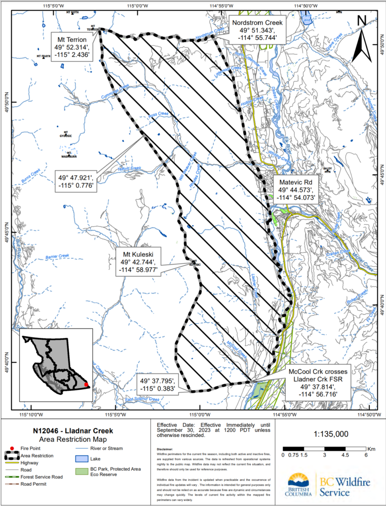
July 26, 2023 – 3:30 pm
July 26, 2023 – 3:30 pm
BC Wildfire Update
District of Sparwood Update
The District would like to remind residents about the importance of preparing and protecting your property by undertaking simple, but important Fire Smart actions. Find the Fire Smart checklist below and learn more at https://firesmartbc.ca/.

July 26, 2023 – 12:30 pm
BC Wildfire Update
Wednesday is forecast to be sunny, warm and dry with variable, but generally light, winds. On Thursday, there is potential for thunderstorms bringing dry lighting and gusting winds. The fire is a smouldering ground fire (rank 1 and 2) with pockets of rank 3 in areas of heavy fuel accumulation. Learn more about wildfire rank. Click on the maps tab for the most recent fire perimeter.
Operations
On Wednesday, heavy equipment and firefighters are putting in machine guard along the BC Hydro right-of-way at the bottom of the slope. Crews are preparing water-delivery systems and establishing hoselay in critical areas.
Crews will be looking for opportunities to conduct small-scale hand ignitions to remove unburnt fuel between the fire edge and control lines in an intentional manner to reduce the chance of the fire spreading beyond control lines. These small-planned ignitions may begin Wednesday if conditions are favourable. Hand ignitions will be ongoing in the coming days when conditions allow. Learn more about planned ignitions here.
Structure protection personnel are on site, assessing and installing equipment to protect structures as needed.
Aviation Resources
Aircraft are assisting ground crews on Wednesday as needed to cool the fire’s edge and slow growth downslope. The fire has moved further downslope and heavy equipment and firefighters are constructing machine guard and wetline to help prevent spread toward the community. Helicopters will bolster those efforts where it is safe and effective to do so.
While wildfire management relies on a fleet of reliable and capable aircraft to assist firefighters on the ground, there are several incidents where the use of aircraft can have unintended negative consequences. It is the job of experienced personnel on the ground, in the zone, in operations, and in aviation to decide whether the use of aircraft would do more harm than good. With ground crews available to help mitigate potential negative impacts, officers will determine how to best use available aviation resources to assist in fire suppression.
July 25, 2023 – 8:00 pm
July 25, 2023 – 8:00 pm
BC Wildfire Update
BC Wildfire and structure protection crews are staying on the fire overnight to continue to monitor growth. A map has been provided outlining the current fire area.

July 25, 2023 – 5:30 pm
July 25, 2023 – 10:50 am
July 25, 2023 – 10:50 am
BC Wildfire Update
Weather is forecast to remain hot and dry on Tuesday, with winds of 30 km/h gusting up to 50.
Fire behaviour remained elevated overnight as winds continued to push the fire downslope burning at rank 1-2 with pockets of rank 3 in areas with heavy fuel accumulation. Learn more about wildfire rank. The fire size is estimated at 150 hectares. Click on the maps tab for the most recent fire perimeter.
On Tuesday, heavy equipment and firefighters are putting in machine guard along the BC Hydro right-of-way at the bottom of the slope. Crews are preparing water-delivery systems and establishing hoselay in critical areas.
Human life and safety remains the BC Wildfire Service’s number one priority.
Aircraft will be flying the fire on Tuesday. The fire has moved further downslope and heavy equipment and firefighters are constructing machine guard and wetline to help prevent spread toward the community. Helicopters are on site and will bolster those efforts where it is safe and effective to do so.
While wildfire management relies on a fleet of reliable and capable aircraft to assist firefighters on the ground, there are several incidents where the use of aircraft can have unintended negative consequences. It is the job of experienced personnel on the ground, in the zone, in operations, and in aviation to decide whether the use of aircraft would do more harm than good. With ground crews available to help mitigate potential negative impacts, officers will determine how to best use available aviation resources to assist in fire suppression.
July 24, 2023 – 8:00 pm
July 24, 2023 – 8:00 pm
BC Wildfire Update
Equipment has been prepositioned in the Sparwood area. Crews are on site overnight Monday to directly monitor fire growth. Tuesday, July 25, heavy equipment and ground crews will begin putting in machine guard in areas where this work can happen safely.
Human life and safety remains the BC Wildfire Service’s number one priority.
Thanks to the cooperation of multiple agencies, hundreds of Evacuation Alerts were safely and efficiently handed out this evening in Sparwood Heights. Big thanks to Sparwood Search and Rescue, Elkford Search and Rescue, Fernie Search and Rescue, and the Elk Valley RCMP for assisting in the distribution of notices.
July 24, 2023 – 12:30 pm
July 24, 2023 – 12:30 pm
BC Wildfire Update
This fire is now a wildfire of note.
Site Conditions and Fire Behaviour
Elevated winds have increased fire behaviour and activity on the Lladnar Creek wildfire. A response officer has flown the fire and the size is now estimated to be 150 hectares. A perimeter map will be provided Monday afternoon or early evening.
Operations
Human life and safety remains the BC Wildfire Service’s number one priority. While the fire has grown and moved down from the ridgetop, it continues to burn in an area that is too steep and mountainous for crews to safely access. Suppression plans for this fire are being finalized. Ground personnel and heavy equipment resources are assigned and will be on the incident by this evening.
Aviation Resources
While wildfire management relies on a fleet of reliable and capable aircraft to assist firefighters on the ground, there are several incidents where the use of aircraft can have unintended negative consequences. It is the job of experienced personnel on the ground, in the zone, in operations, and in aviation that must decide whether the use of aircraft can do more harm than good.
Bucketing in steep terrain can wash burning debris downslope. Additionally, the heavy winds that helicopter rotors create can cast burning embers and start unintended spot fires that then also have to be suppressed.
Bucketing operations or dropping retardant alone will very rarely create a fires edge. In steep terrain with the heavy fuels in this area, crews on the ground are needed to bolster the work being done by aircraft. When crews are unable to safely access a fire, the chances of bucketing having a negative effects go up.
Public and responder safety is our number one priority and this includes the safety of the pilots. Flying is a high-risk activity, and sustained bucketing at high altitudes significantly increases that risk. As the fire sits now aviation resources will be unable to work directly on active fire suppression due to the increased probability of negative impacts, decreased likelihood of successfully achieving objectives, and the risk to both fixed and rotary wing pilots.
Updates will be provided on all official news sources as they become available
July 23, 2023 – 4:15 pm
July 23, 2023 – 4:15 pm
The BC Wildfire Service has provided the following update on the Lladnar Creek Wildfire N12046.
• This fire originated at high elevation on a ridgetop. Airtankers and helicopters worked steadily on this fire July 22 to slow fire growth.
• An Initial Attack crew assessed the site for access and egress (exit) options to the fire and found no safe options. As it is burning in very steep and rocky terrain, crews are not able to work on this fire directly where it sits.
• This fire is now listed as a modified response. A camera has been set up so that response officers can monitor the fire daily. A fire analysis is being developed that will include a suppression plan that will be activated when the fire reaches an area that crews will be able to work on it.
• BC Wildfire Service staff work continually to ensure that the most appropriate firefighting equipment is available to help protect our communities, natural resources, and infrastructure from wildfire risks. While airtankers and helicopters were initially working the fire, it is unlikely that aviation resources will be back until crews are able to safely work on it.
• Flying is a high-risk activity and sustained bucketing at high altitudes in high temperatures increases that risk. Bucketing or dropping retardant alone will very rarely create a fires edge. In steep terrain with the heavy fuels in this area, crews on the ground are needed to bolster the work being done by aircraft.
• When crews are unable to safely access a fire, the chances of bucketing having a negative effects go up.
For information and resources visit https://sparwood.ca/wildfire-southwest-of-sparwood-fire…/, https://www.rdek.bc.ca/…/emerg…/evacuation_alerts_orders, and BC Wildfire at https://wildfiresituation.nrs.gov.bc.ca/map.
We will provide continued updates as we receive them from BC Wildfire Service.
July 23, 2023 – 12:00 pm – Evacuation Alert
July 23, 2023 – 12:00 pm
EVACUATION ALERT
July 23, 2023, at 12:00 hours
An Evacuation Alert has been issued by the District of Sparwood due to wildfire threat and the potential danger to life and health for the residents within the District of Sparwood as outlined on the attached map for the following properties:
1) 1240 Matevic Road
2) 1280 Matevic Road
3) 1300 Matevic Road
4) 1400 Matevic Road
The purpose of this Alert is to prepare you to evacuate your premises or property if necessary. You will be given as much advance notice as possible prior to evacuation; however, you may receive limited notice due to changing conditions.
While the Evacuation Alert is in place, you should prepare for a possible Evacuation Order by:
- Locating all household members and designate a meeting point outside the evacuation area.
- Have a ‘To-Go Bag’ packed and ready to leave at a moment’s notice, with essential items such as government-issued ID, medications, money, clothing, personal care items, important documents (e.g. insurance, banking and mortgage info), valuables and keepsakes.
- Preparing to move any disabled persons and/or children.
- Pre-register all household members on the provincial Evacuee Registration & Assistance (ERA) Tool at http://ess.gov.bc.ca
- Moving pets and livestock to a safe area.
- Making transportation arrangements for your household members in the event of an Evacuation Order.
- Arranging accommodation for your family if possible. In the event of an evacuation, Reception Centres will be opened if required.
- Monitoring news sources for information on Evacuation Orders and locations of Reception Centres.
- Register for the Regional Evacuation Notification System on the Regional District of East Kootenay’s website at www.rdek.bc.ca – this will ensure that we can reach you rapidly if the evacuation status changes.
Further information will be issued should the situation change; updates will be provided on the District of Sparwood website (www.sparwood.bc.ca), Facebook & Instagram pages. Information can also be accessed by calling the District of Sparwood Information line at 250-425-6834.
If you are not already on the District of Sparwood’s Community Newsletter list and would like to be added for emergency notifications, https://sparwood.ca/reidents/newsletter-signup/.
THIS IS ONLY AN ALERT MEANT TO HELP YOU PREPARE IN THE EVENT EVACUATION IS REQUIRED. SHOULD THE SITUATION CHANGE, AN EVACUATION ORDER WILL BE ISSUED.
David Wilks
Mayor, District of Sparwood
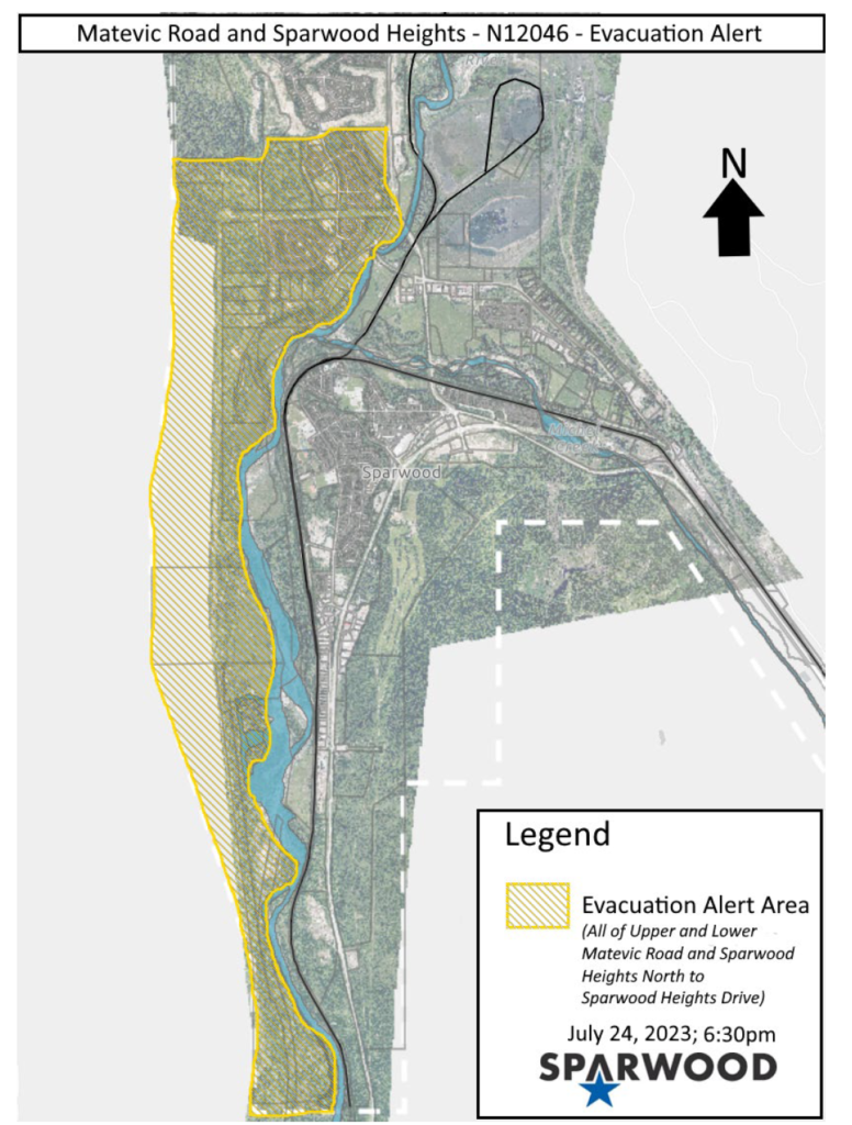
July 22, 2023 – 9:19 pm
July 22, 2023 – 9:19 pm – Update: Lladnar Creek Fire, N12046
Air tankers have been working on the fire today to slow fire growth as the fire is burning in steep terrain. An Initial Attack Crew was on site to assess for potential access and egress options. The BC Wildfire Service is hoping to get a track of the fire so that a more accurate size can be mapped.
The District is working very closely with BC Wildfire and the Regional District of East Kootenay (RDEK). The safety of the public is aways the highest priority. Residents of the District of Sparwood can find up-to-date information on the District social media pages, the website, the RDEK at https://www.rdek.bc.ca/departments/protectiveservices/emergencyinfo/evacuation_alerts_orders, and BC Wildfire at https://wildfiresituation.nrs.gov.bc.ca/map.
As always, preparedness is key. Should there be an evacuation alert or order notifications will be posted on all official communication platforms and door-to-door notifications will be made. Residents are also strongly encouraged to sign up for the RDEK Evacuation Notification System at https://www.rdek.bc.ca/departments/protectiveservices/emergencyinfo/evacuation_notification_system/..
To help prepare for an alert or order, find preparedness checklists at https://www.rdek.bc.ca/departments/protectiveservices/emergencyinfo/prepare/. Information and resources can also be found at https://sparwood.ca/residents/emergency-services/.
July 21, 2023 – 7:25 pm
July 21, 2023 – 7:25 pm
Sparwood Fire and BC Wildfire are both aware of the fire on the backside of the ridge Southwest of the municipality.
Thanks to everyone who noticed and reported the fire. This fire is now on the BC Wildfire map (fire #N12046) and updates will be made by the BC Wildfire team on https://wildfiresituation.nrs.gov.bc.ca/map.
Updates will be posted as they are available.
During any emergency, the Regional District of East Kootenay will provide information through the Evacuation Notification System, keeping residents and property owners informed in case of evacuation orders or alerts during critical events such as wildfires, floods or hazardous materials incidents. To learn more and sign up visit https://www.rdek.bc.ca/departments/protectiveservices/emergencyinfo/evacuation_notification_system/.
Other Important Resources Are:
Regional District of East Kootenay – www.rdek.bc.ca
Wildfire BC – www.wildfirebc.ca
Fire Smart BC – firesmartbc.ca

Post Date: July 21, 2023 | Category: News & Updates